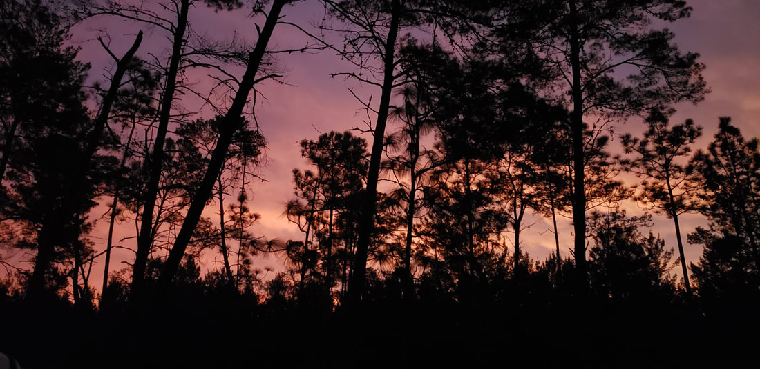
Central Florida's granddaddy of long distance, cross country, single track bicycle trails, the Paisley Woods Bicycle Trail located within the Ocala National Forest is 22.2 miles of true back-woods adventure.
Non 4-wheel drive access locations, LAT/LON Coordinates: * 28.976760, -81.550139 Clearwater Lake Trailhead * 29.068435, -81.581237 North Trailhead on FR-69 * 29.078186, -81.577677 Alexander Springs Main Gate
4-wheel drive access locations: * Each place the bicycle trail crosses a numbered road. * See maps on the downloads page.
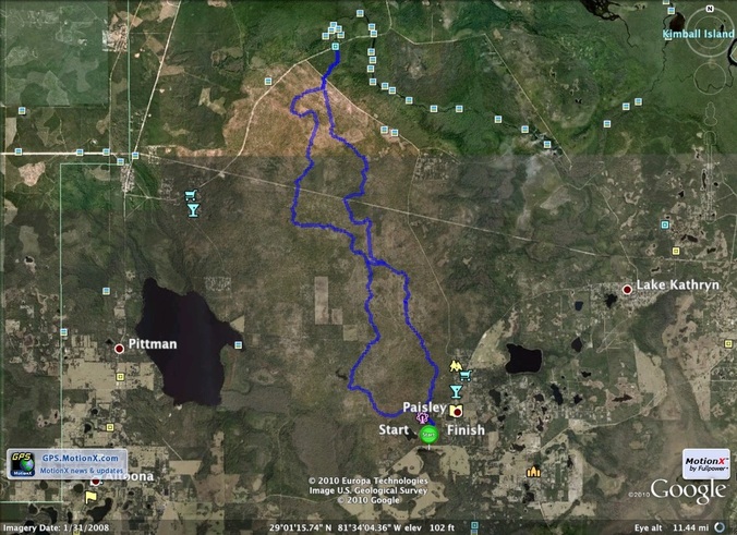
Trail Location: Immediately NW of the town of Paisley, Florida, the trail runs between the Clearwater Lake Recreation Area at the south end and the Alexander Springs Recreation Area at the north end.
Water and Restrooms: At the recreation areas at either end.
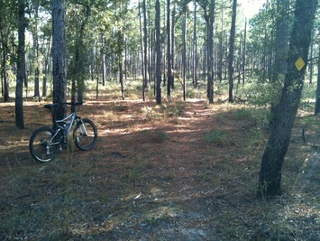
Trail Conditions: This is an off-road trail system, plan accordingly. The trail is in optimal shape due to recent maintenance and overall improvements. Soft, sandy sections exist but are short, rare and widely spaced. Fast riders on competition grade equipment regularly ride the system without putting a foot down.
Availability : The entire trail system is currently open 24 - 7 - 365.
General Notes: Periodic "mid-level mowing" operations are conducted by the Forest Service. In selected areas anything taller than 30" and less than 8" in diameter at chest height is "mowed" - other than long leaf pine which is usually untouched. The purpose of this mowing operation is two-fold: (1) return the ecosystem to near original tree composition of primarily long leaf pine, and (2) encourage continued re-population of the once plentiful Red-Cockaded Woodpecker. Long leaf pines marked with a wide, white painted band and a metal plate with a serial number, are found throughout the Paisley Woods and are homes for these small birds which are federally protected.
Follow the 5" x 7" yellow diamonds that are found mounted to trees along the length of the trail system.
At each numbered forest road crossing there is a yellow Carsonite signpost. At the bottom of the sticker stack on each post is a yellow sticker showing the road number being crossed at that location. If you have one of the detail trail maps with you (see downloads page), you can determine your exact location at each forest road crossing.
Prescribed Burns: The Forest Service conducts planned, periodic, prescribed burns to manage the long leaf pine and wiregrass ecosystem, usually prescribed burns are a one day event. The goal is to burn individual sections or "blocks" bounded by jeep roads every other year, done in an alternating patchwork fashion. They do not burn the entire Paisley Woods in one calendar year. The vegetation recovers very quickly, new sprouts begin to show within days and things are back to near normal in just a few months. Planned prescribed burns are usually scheduled to occur between January and July each year, are highly weather dependent, and typically a burn event will be conducted during morning hours, the afternoon is for mop up. During this time of year, trail maintenance volunteers clear flammable material away from the yellow Carsonite trail signposts to protect them from being burned.
A PWBT area map that shows all of the forest road numbers in the area.
Another PWBT "big picture" map that doesn't include the forest road detail but does show the distances between notable landmarks.
An Excel file which includes mileage distances between each numbered road and/or significant landmark. This file contains two worksheets, one for the north loop, another for the south loop.
Distance Notes:
The Clearwater Lake Loop (aka the south loop) is 9.6 miles in length.
The Alexander Springs Loop (aka the north loop) is 12.9 miles in length.
The "center connector" is 0.3 miles in length and is very close to a place in the woods known locally as "5-Point", a spot where 5 jeep trails intersect. Driving directions to the west end of the center connector ... from the 5-point intersection travel south on FR-63 about 1,000 feet and then a short distance to the east at the first jeep trail on the left. A 4wd vehicle is required to reach this location by jeep trail.
Equipment Needed:
Any bicycle wearing fat off-road tires will work.
The wider and/or taller the wheel the better, 2.0" to 2.5" wide tires work well, 4" fat-bike tires work extremely well - sand becomes literally a non-issue.
Tire liners provide inner tube puncture resistance year round and are especially useful during the September through October sand-spur season.
Suspension isn't required but makes the ride more comfortable.
Bring what you might need such as an inner tube repair kit, minimal bike tool kit, clothes to layer up/down as needed, water, snacks, flashlight(s), spare batteries, maps, mileage tables from the Downloads page, etc.
Carrying a flashlight might seem unimportant while the sun is up, but if caught on the trail after dark, you - will - need - a - flashlight. Many of us actually ride intentionally at night, especially during the hot summer months.
If you carry it in ... please carry it out. And if you see litter left by others, help us by taking that out with you as well, thanks.
Hunting season notes: Riding during deer hunting season is allowed, but:
We do recommend wearing the same kind of hunter safety orange colored vest that hunters are required to wear, available at your local Walmart or sporting goods store for around $10.
See the Downloads page for a link to Ocala National Forest hunting season information, or do a web search as needed.
Non-4WD Access: There are three "ride from" locations that can be easily accessed by non-4wd vehicles.
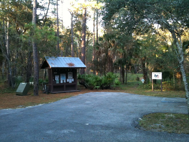
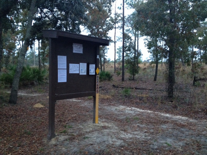
Clearwater Lake Trailhead (shown above): When turning off county road CR-42 heading into the Clearwater Lake Recreation Area the PWBT trailhead kiosk is on the right. Paved parking is available.
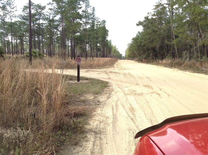
North Trailhead (shown below): The north trailhead is on graded clay forest road FR-69 (aka Paisley Road) about 1/3 mile east of county road CR-445 near Alexander Springs. There is a 6" x 6" post on the south side of FR-69 that has a mountain bike sign on it, turn in there headed south and travel about 100 yards to the parking area next to the small kiosk shown below.
Alexander Springs: The very north end of the bike trail begins directly across the road from the Alexander Springs Recreation Area main gate which is on paved county road CR-445 about 1/2 mile N/E of the CR-445/FR-69 intersection. Parking on the shoulders of CR-445 across from the Alexander Springs main gate is not permitted. Parking is available inside the Alexander Springs recreation area gate for a small fee. The attendant can tell you what time the gate will be locked that evening for the day in question, time varies with the seasons.
4WD Access:
If you have access to a 4wd vehicle, consider exploring the numerous 4wd "jeep" trails that crisscross the approximately 50 square miles of the Paisley Woods area. These jeep trails offer many hours of exploration fun, and provide numerous additional PWBT "ride from" locations. See the Downloads page for a map that shows all numbered forest roads (jeep trails) with a bike trail overlay.
To download a free copy of the current Ocala Forest Motor Vehicle Use Map (MVUM) book please visit the downloads page or do a web search for it. It is updated annually.
Here is a photo of the South Trailhead Kiosk at the Clearwater Lake Recreation Area.
Here is a photo of the North Trailhead Kiosk which is on Forest Road 69 near paved road 445, the kiosk is visible to the south from FR-69.
This is the North Trailhead sign on graded road FR-69, looking west, turn left at the sign and the North Kiosk (in the photo above) is about 400 feet to the south. In the far distance just over the rise you can see the trees on the west side of 445, drive straight ahead to 445 and turn right to go to Alexander Springs.